
Two hundred and fifty million years ago — during the Permian period, when the supercontinent Pangaea was still assembling itself — the area now occupied by Ninh Binh province lay beneath a shallow tropical sea. The limestone deposited on that seafloor, compressed and uplifted through subsequent geological convulsions, now forms the ninh binh karst landscape that UNESCO inscribed as a World Heritage site in 2014.
This guide examines the geology behind the scenery — because understanding why these towers exist makes looking at them rather more interesting than simply noting that they are, indeed, tall.
At a glance:
- Geological age: 250 million years (Permian limestone)
- Karst type: Tower karst (fenglin) — vertical towers with flat alluvial plains
- UNESCO designation: Trang An Landscape Complex (2014, mixed heritage)
- Area: 6,172 hectares (core zone) + 6,268 hectares (buffer)
- Caves documented: 49 (Trang An system alone)
- Best viewpoints: 7 accessible sites (see table below)
How Ninh Binh’s Karst Formed
The ninh binh karst formation involves three geological processes operating across vastly different timescales:
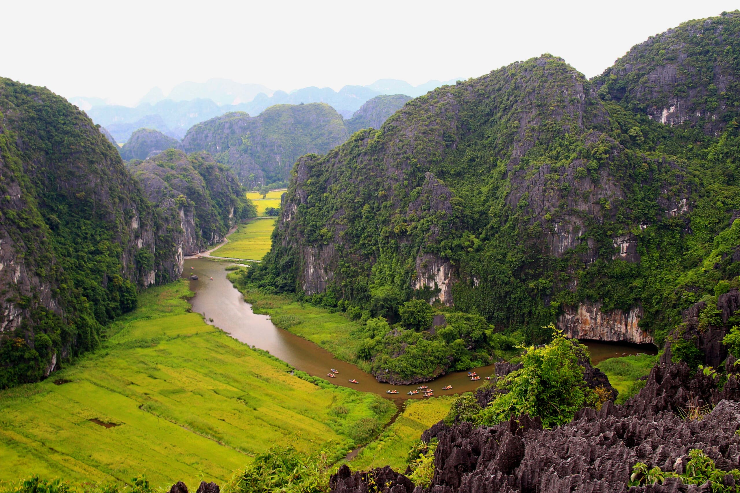
- Deposition (250–200 million years ago): Calcium carbonate from marine organisms accumulated on the Permian seafloor, forming limestone beds up to 1,000 metres thick. The fossils of crinoids, brachiopods, and coral visible in exposed rock faces throughout the province date to this period.
- Uplift (65–23 million years ago): Tectonic activity associated with the Indian plate’s collision with Asia elevated the limestone platform above sea level. Fracture networks created during uplift established the drainage patterns that would subsequently dissolve the rock.
- Dissolution (23 million years to present): Tropical rainfall, slightly acidified by atmospheric CO2, slowly dissolved limestone along fracture lines — widening cracks into channels, channels into caves, and caves into the vertical-walled towers visible today. The process continues at approximately 0.05 mm per year.
📚 Historical Note: The geological term for Ninh Binh’s landscape is “tower karst” or fenglin (峰林) — literally “peak forest” in Chinese geological terminology. It is distinguished from “cone karst” (fengcong) by the presence of flat alluvial plains between towers, rather than interconnected ridges. Guilin (China) and Viñales (Cuba) are the closest geological analogues — a comparison that is geologically precise and touristically instructive.
The 7 Best Karst Viewpoints
| # | Viewpoint | Elevation | Access | Best For |
|---|---|---|---|---|
| 1 | Mua Cave summit | 120m | 486 steps (30 min) | Tam Coc valley panorama, sunset |
| 2 | Trang An ridge trail | 150m | Hiking (1.5h from boat station) | UNESCO core zone, dawn |
| 3 | Bai Dinh bell tower | 80m | Electric car + stairs | Western karst range, afternoon |
| 4 | Van Long dyke path | 5m | Flat walk (30 min) | Reflections in still water, morning |
| 5 | Hang Mua extended ridge | 140m | Scramble beyond summit (45 min) | Empty viewpoint, sunset |
| 6 | Tam Chuc boat approach | Lake level | Electric boat (15 min) | Karst towers from water, any time |
| 7 | Provincial Road 477C (Ninh Van) | Road level | Cycling/driving | Roadside karst walls, afternoon light |
Why UNESCO Chose Trang An
The 2014 inscription was unusual in two respects. First, it was a mixed natural-cultural designation — only the 39th in the world at that time. Second, the cultural component was not architectural but archaeological: evidence of continuous human habitation in the karst caves spanning 30,000 years, from Palaeolithic hunter-gatherers through Neolithic farmers to the Đinh dynasty court.
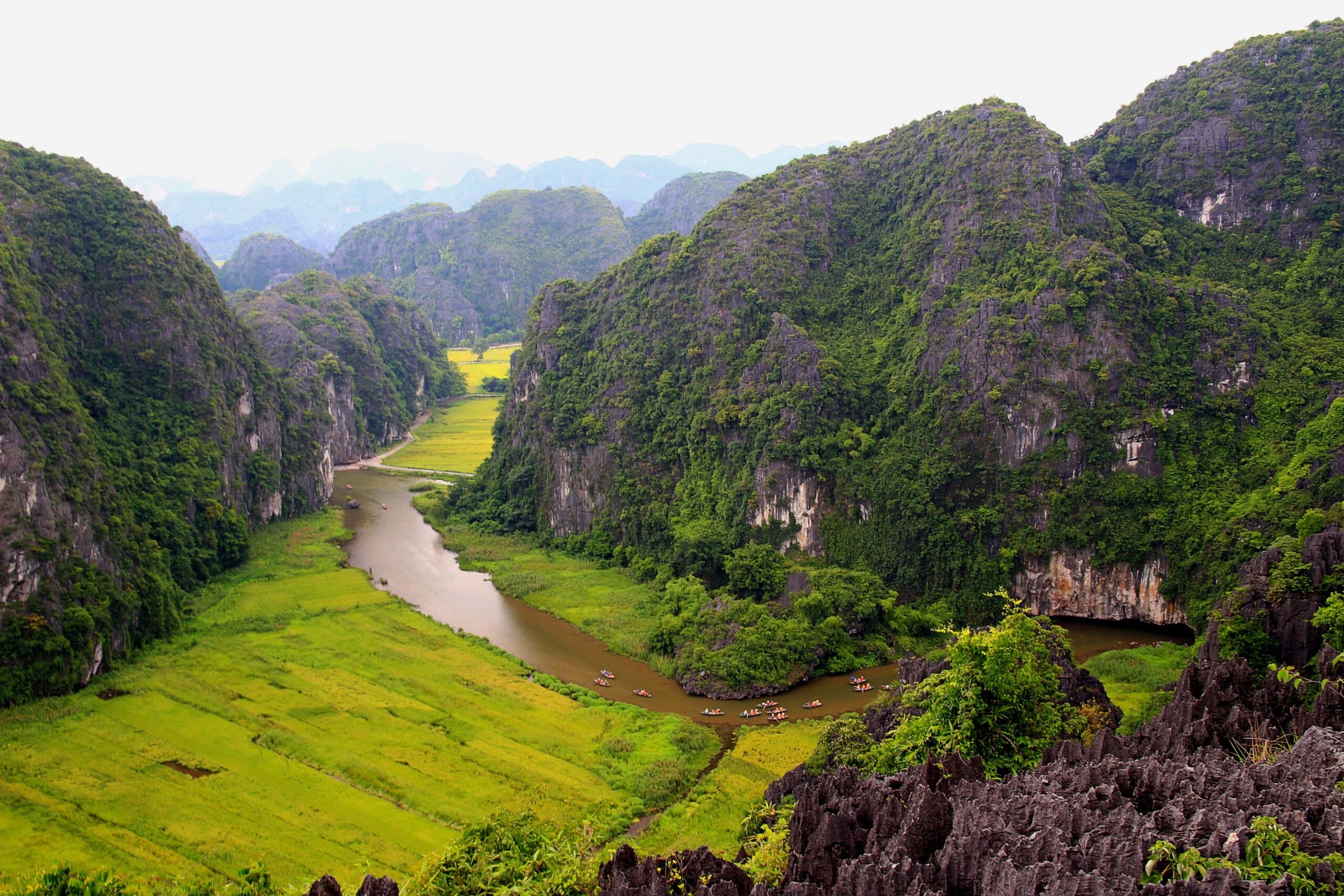
The karst caves served as natural shelters, freshwater sources, and (during the Đinh period) strategic fortifications. The geological feature that makes Ninh Binh photogenic — vertical limestone walls with flat valleys between them — is precisely the feature that made it militarily defensible a millennium ago.
Geological Features You Can See
- Fossil beds: Exposed at Tam Coc cave entrances — look for circular crinoid stems and shell fragments in the limestone walls
- Solution cavities: The horizontal cave layers visible on cliff faces mark former water table levels — each line represents thousands of years of dissolution
- Terra rossa: The red-orange soil at the base of karst towers is an insoluble residue of dissolved limestone — it takes approximately 10,000 tonnes of dissolved rock to produce 1 metre of terra rossa
- Phytokarst: The pitted, sharp-edged surface of exposed limestone (painful to touch) is created by blue-green algae dissolving the rock surface — a biological rather than chemical process
📌 Book this experience:
Explore Ninh Binh tours on Klook | Browse on Klook
Some links are affiliate links. We earn a small commission at no extra cost to you.
For travelers looking to arrange geological tours and karst exploration in advance, I have found that you can find karst landscape tours on 12Go with verified operators and instant confirmation.
FAQ
How old is the Ninh Binh karst landscape?
The limestone was deposited 250 million years ago during the Permian period. Karst tower formation began approximately 23 million years ago through tropical rainfall dissolution. The process continues today at ~0.05 mm per year.

What type of karst is Ninh Binh?
Tower karst (fenglin) — vertical limestone towers rising from flat alluvial plains. Geologically comparable to Guilin (China) and Viñales (Cuba). Distinguished from cone karst by the flat plains between towers.
Where is the best viewpoint for Ninh Binh karst?
Mua Cave summit (486 steps, 120m) offers the most accessible panorama over the Tam Coc valley. For fewer crowds, the extended ridge beyond the summit provides equal views with no other visitors. Van Long offers the best water reflections at dawn.
Disclosure: Some links in this article are affiliate links. If you book through them, we earn a small commission at no extra cost to you.
You might also enjoy: the UNESCO-inscribed Trang An landscape.
For further reading: Ninh Binh province on Wikipedia.
Frequently Asked Questions
How old are the karst formations in Ninh Binh?
Ninh Binh’s limestone karst dates to the late Permian and Triassic periods, approximately 250 million years ago, when ancient seabeds deposited the calcium carbonate layers that subsequent tectonic uplift and water erosion sculpted into the tower karst visible today. This geological timeline makes Ninh Binh’s formations contemporaneous with Ha Long Bay’s maritime karst — both emerged from the same limestone platform before sea-level changes separated them.
What makes Ninh Binh’s karst landscape unique compared to other karst regions?
Ninh Binh represents one of the world’s finest examples of tower karst or fenglin topography, where isolated limestone towers rise abruptly from flat alluvial plains rather than forming connected ridgelines. UNESCO recognized this distinction in 2014 by inscribing the Trang An Landscape Complex as a mixed World Heritage Site, acknowledging both its geological significance and 30,000 years of continuous human habitation documented through cave archaeology.
Where are the best viewpoints to appreciate Ninh Binh’s karst landscape?
The Mua Cave summit (500 steps, 15-20 minutes) provides the most iconic aerial perspective over the Tam Coc river valley and its surrounding karst towers. For a less crowded vantage, the viewpoint at Trang An’s ecological zone offers comparable panoramas with a fraction of the foot traffic. Photographers should note that early morning mist between 6:00-7:30 AM creates the layered atmospheric effect that defines Ninh Binh’s most celebrated images.