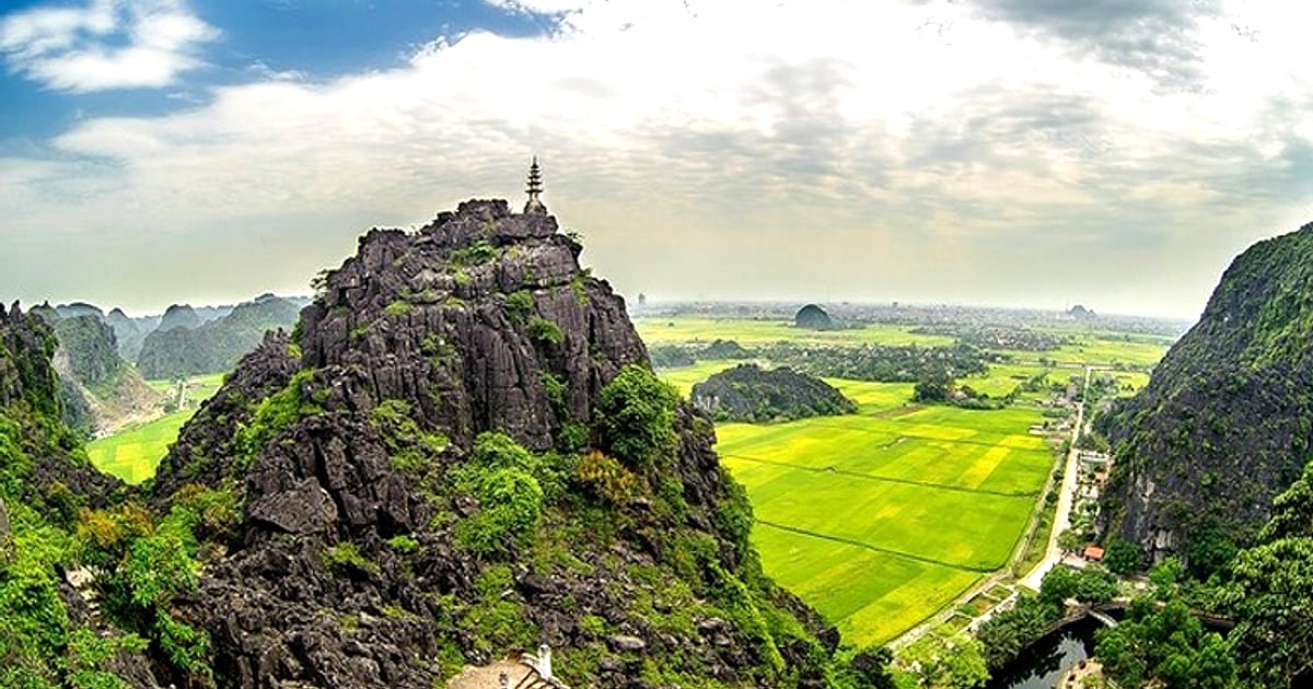
The karst landscape of Ninh Bình — limestone towers rising vertically from flat rice paddies, rivers threading through cave systems, temples nestled in cliff hollows — is, from above, one of the most photogenic terrains in Southeast Asia. Ninh Binh drone photography has produced some of the region’s most shared aerial images. It has also produced several confiscated drones, because Vietnam’s drone regulations are genuine, enforced, and more restrictive than most visitors expect.
At a glance:
- Ninh Binh drone photography: Legally possible but requires registration with Civil Aviation Authority of Vietnam (CAAV)
- Registration: Mandatory for ALL drones regardless of weight — apply 15 days before flight
- Restricted zones: Trang An UNESCO area and military installations — NO exceptions
- Best legal locations: Bích Đông Road rice paddies, Mua Cave vicinity (outside restricted perimeter)
Vietnam Drone Regulations (2026)
| Requirement | Detail |
|---|---|
| Registration | Mandatory — CAAV application ≥15 days before flight |
| Fee | Registration fee varies; expedited processing available |
| No-fly zones | Military areas, airports, UNESCO Trang An core zone |
| Max altitude | 120 metres AGL (above ground level) |
| Time restrictions | Daylight only (sunrise to sunset) |
| Penalties | Unregistered flight: drone confiscation + fine 3,000,000–5,000,000 VND |
Best Ninh Binh Drone Photography Locations
- Bích Đông Road rice paddies: The classic aerial composition — karst towers rising from paddy fields. No flight restrictions. Best during golden rice season (September) or green paddies (April). The photography guide covers ground-level alternatives.
- Tam Coc river corridor: The sampan route through karst formations produces stunning aerial footage. Fly from the pier area, not from within the cave passage. Morning light (06:00–08:00) is optimal.
- Hoa Lư temple complex: Aerial views of Hoa Lư temples against karst backdrop. Respectful altitude — keep above 50m over worship areas.
- Van Long Wetland: Mirror-water reflections with karst. Wildlife disturbance considerations — maintain distance from bird colonies.
Practical Tips for Ninh Binh Drone Photography
- Register early: CAAV processing takes 7–15 working days. Apply before departing your home country
- Local awareness: Inform your accommodation host before flying — they may know of local sensitivities
- Wind: Karst valleys create unpredictable wind patterns. The narrow Tam Coc corridor is particularly turbulent
- Battery: Cold December mornings (10–15°C) reduce battery life by 15–20%. Carry spares
- Respect: Do not fly over people, active boat routes, or temple ceremonies
Ninh Binh drone photography produces extraordinary results — the aerial perspective reveals landscape patterns invisible from the ground. The regulatory framework is the price of that access, and it is, in the broader scheme of things, a modest one. For ground-based alternatives that require no registration and no risk, the photography guide covers the Mua Cave panorama and other elevated viewpoints that approximate the aerial perspective without the bureaucracy.
This article contains affiliate links. When you book through our partner links, we may earn a small commission at no additional cost to you.
📌 Book this experience:
Check Ninh Binh tours on Klook | Browse on Klook
Some links are affiliate links. We earn a small commission at no extra cost to you.
Related: Photography Guide | Tam Coc | Mua Cave
For further reading: Lonely Planet’s Ninh Binh overview.
For those planning ahead, I have found that you can find guided photography tours on 12Go with confirmed availability and transparent pricing.
Frequently Asked Questions
Is it legal to fly a drone in Ninh Binh?
Vietnam’s 2020 Civil Aviation Authority regulations require all drone operators to obtain a flight permit from the local People’s Committee and register their aircraft, a process that takes 7-15 business days and is impractical for most tourists. Within the UNESCO-listed Trang An Landscape Complex, drone flights are explicitly prohibited by site management to protect both wildlife habitats and the visitor experience. Enforcement has increased since 2022, with confiscation reported at Tam Coc, Mua Cave, and the Hoa Lu Ancient Capital perimeter.
Where can I get aerial photography of Ninh Binh without a drone?
The summit of Mua Cave (Hang Mua) at 486 steps provides the most iconic elevated perspective over the Tam Coc valley, replicating much of what a drone would capture at 100-150 meter altitude. The upper viewpoint at Bai Dinh Pagoda’s bell tower offers a sweeping westward panorama across the karst field, and the limestone cliff behind Bich Dong Pagoda provides another elevated vantage requiring a short scramble. Several tour operators also offer helicopter charters from Hanoi that overfly the Trang An complex, though at considerable cost of approximately 15,000,000 VND per hour.
What penalties exist for unauthorized drone use in Ninh Binh?
Vietnamese authorities can impose fines ranging from 3,000,000 to 40,000,000 VND for unlicensed drone operation, with equipment confiscation as an additional consequence. At UNESCO-managed sites like Trang An, security personnel actively monitor for drone activity and will approach operators immediately. The most pragmatic approach for aerial content is to arrange permitted flights through a licensed Vietnamese drone operator, several of whom advertise services in Ninh Binh starting at approximately 2,000,000 VND per session.